Orchard Crossing Corporate Park
33 Mile & McKay Roads
Bruce Township, MI 48065
CITY
Bruce Township
COUNTY
Macomb
ACRES
29.33 Acres
PRICE
Contact
ZONING
M1 – Light Industrial
DOWNLOAD
Marketing Flyer
Property Description
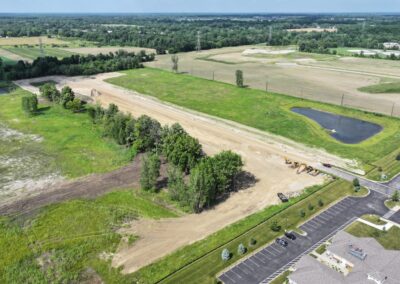
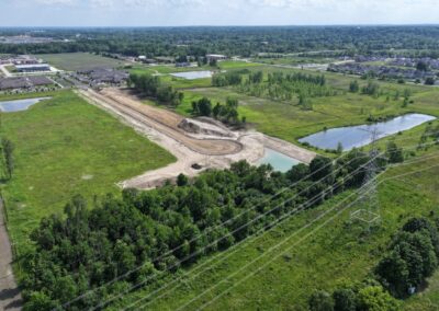
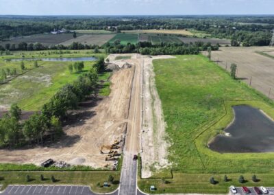
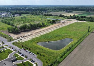
Orchard Crossing Corporate Park is a 29-acre industrial site located at 33 Mile and McKay Roads in Bruce Township, MI. The property is well connected to infrastructure, benefiting from proximity to M-53 (Van Dyke Freeway).
In 2024, the site underwent a comprehensive due diligence review through the VIP program, including a detailed site condition analysis, comprehensive information on utility providers and capacity, and a comprehensive report on site details (full report in the document library below).
Zoning and Land Use
Zoning: M-1 Light Manufacturing District
Current Land Use: Vacant Land
Future Land Use: Industrial
Site Conditions
Greenfield or Brownfield: Greenfield
Above ground structures: None. Orchard Crossing Lane will be extended into the center of the property, ending with a cul-de-sac.
Floodplain: This site is not located in the 100 or 500 year floodplain.
Wetlands:
- No mapped wetlands on the site per EGLE Wetland Map Viewer
- Two potential open water features indicated by aerial imagery
Topographic Elevation: Elevation of the site ranges between approximately 760 and 766 feet above sea level
Soil Types:
- Boyer Sandy Loams (BsA), 0 to 2 percent slopes
- Wasepi Sandy Loam, Silty subsoil variant (WuB), 0 to 4 percent slopes
- Locke Sandy Loam (LoA), 0 to 2 percent slopes
Easements:
- 66-foot-wide Consumers Energy easement along the southern property line (L.1909, P.962); (L.2308, P.889); (L.19419, P.673)
- 20-foot-wide storm sewer easement for the existing storm sewer connecting the detention basins (L.23111, P.290); (L.23140, P.44); (L.23140, P.41)
- 25-foot-wide tree clearing easement for ITC along the northern property line (L.3441, P471); (L.10687, P.570); (L.13188, P.544)
- 66-foot-wide private road easement (L.23111, P.281)
- 20-foot-wide sanitary sewer easement
- 20-foot-wide water main easement
- 15-foot-wide utility easement on the east property line
- Detention basin easement at the northwest corner of the property
- 12-foot-wide drainage easement off property conveys drainage through ITC property to the north branch of the Clinton River to the east (L.15494, P.69 – 73)
Utilities

Electric
Provider: DTE Energy
Capacity to Serve Demand:
- Short Term Capacity: 4 MW
- Long Term Capacity: 7 MW
Assumed Demand: 7 MW
Nearby Infrastructure Detail:
- 13.2 kV distribution line along east side of site
- 40 kV sub-transmission line 1 mile from site
- 120 – 345 kV transmission lines adjacent to north side of site and 0.3 miles west of site

Natural Gas
Provider: Consumers Energy
Capacity to Serve Demand: Existing system can meet the assumed demand
Assumed Demand: 13 MCFH (mcf/hour)
Nearby Infrastructure Detail:
- 2-inch plastic distribution gas line with MAOP (maximum allowable operating pressure) of 55 PSI (pounds per square inch) is located under Orchard Crossing Lane.

Water
Provider: Great Lake Water Authority (GLWA) and Bruce Township
Capacity to Serve Demand:
- 115 REU (residential equivalent units) are allocated to this parcel
- Average flow = 44,700 GPD
- Max design flow = 89,400 GPD
Assumed Demand: 50,000 GPD – 150,000 GPD
Nearby Infrastructure Detail:
- 12-inch water main on the east side of Orchard Crossing Lane is stubbed at the southern property line of the site.

Sewer
Provider: Bruce Township
Capacity to Serve Demand:
- 115 REU (residential equivalent
units) are allocated to this
parcel - Average flow = 34,500 GPD
Assumed Demand: 40,000 GPD – 100,000 GPD
Nearby Infrastructure Detail: 12-inch sanitary sewer is stubbed on the property near the southwest corner of the property
Workforce Data
30-Minute Drive
805,929
Population
24,477
Total Businesses
324,575
Active Workforce
60-Minute Drive
3,704,373
Population
130,491
Total Businesses
1,746,944
Active Workforce
Transportation
Proximity to Highways
Site access on Orchard Crossing Lane from 33 Mile Road
0.5 miles to M-53 access
15 miles to I-69 access
20 Miles to I-94 access
Proximity to Rail
12 miles to Class 1 Canadian National Railroad
12 miles to Consolidated Rail Corp. Railroad
27 miles to Canadian National Railway Moterm terminal located at 600 Fern Street, Ferndale, M
Proximity to Airports
PROXIMITY TO AIRPORTS
60 miles to Detroit Metro Airport (Romulus, MI)
52 miles to Bishop International Airport (Flint, MI)
Document Library
Site Assessment Report with Site Maps
Marketing Flyer
Demographic & Business Data
Workforce Profile
Regional Overview
Site Contacts
Site Representative
Michael D’Agostini
Quadrate Development
Phone: (810) 560-4220
County Contact
Jack Johns
Program Director
Macomb County Planning and Economic Development Department
Email: jack.johns@macombgov.org
Phone: (586) 256-7487
Program Contact

Shannon Selby
Vice President of Real Estate


